Two NordicLink Master’s degrees
Øystein Grasdal and Ole Fjellstad Holt finished their UiO master’s degrees on NordicLink projects related to infrastructure exposure to landslides and floods in June!

The MSc projects focused on the NordicLink case study area around Otta in upper Gudbrandsdalen where they estimated hazard probability and quantified risk accounting for costs related to damage and closure along the roads and railways, both in todays and future climate scenarios. Both MSc theses were examined in June and awarded with very good grades! Congratulations!
Master Thesis by Øystein Grasdal:
” Infrastructure exposure to shallow landslides in upper Gudbrandsdalen – Predicting the impact of climate change using the TRIGRS and RAMMS models”
Linear infrastructure networks, such as roads and railways, are of great social and economic importance in connecting the different regions of Norway. Landslides are cause of unexpected traffic flow disruptions of significant societal cost every year, costs which are expected to increase in the future with climatic and demographic changes. This study presents a combination of the two physically based models TRIGRS and RAMMS to produce a hazard chain from intense rainfall to subsequent landslide initiation and runout for a case study site in upper Gudbrandsdalen in South-Eastern Norway. By implementing a climate factor to the precipitation intensity, the climatic effect is traced through the hazard chain, successfully illustrating future change in infrastructure exposure to landslides. A significant increase of unstable slope areas with response to climate induced increase in precipitation intensity is observed for extreme rainfall events of 20-, 50-, 100- and 200-year return period. Similar results are observed for the runout simulations, where the climatic effect is seen as an increase in both runout volume and spatial distribution of flow. The runout analysis outlines the historically most active parts of the study area, with six out of seven documented landslides occurring within the modelled sections of exposed road and railway. The uncertainty of the model is well illustrated by a poor match to both release areas and runout footprint of the landslide events subject to calibration of the model. Model accuracy is limited due to shortcomings of data for the calibration event, input detail of physical characteristics of surface and sub-surface, as well as uncertainty related to the landslide release mechanisms. Although the practical utility of the coupled model is thereby limited in terms of accurate landslide prediction, the results illustrate how it may be utilized in remotely based assessments of hazard hot-spots and assist in selection of sites suitable for risk-reducing measures.

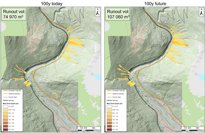
Figure 1: RAMMS runout simulation of landslides initiated by precipitation events of 100-year return period with today’s climate (left) and for a climate scenario with +20% precipitation (right).
Master Thesis by Ole Fjellstad Holt:
“Floods in Otta, an analysis of direct and indirect consequences for roads and railways.”
Ole Fjellstad Holt has written the MSc thesis “Floods in Otta, an analysis of direct and indirect consequences for roads and railways.” The thesis was part of the WP2, with Anders Solheim (NGI) and Kolbjørn Engeland (University of Oslo) as supervisors. The thesis was rewarded grade A.
The Otta valley is vulnerable to both direct and indirect damage of flooding, and frequency of road and railway closures are expected to increase with the prospected future changes in climate. This study investigates the consequences of floods in the rivers Gudbrandsdalslågen and Otta. Flood maps and duration of flooding above certain floods levels are modelled for a range of discharges representing different return periods from 5- to 200-years, using the HEC-RAS program. The flood hazard maps are related to roads and railways, and damage and cost calculations are performed. Both direct costs from damage, as indirect cost of road closures, such as loss of time and vehicle costs are considered. To account for future changes in climate all flood simulations are also run with a 20% increase in flood discharge.
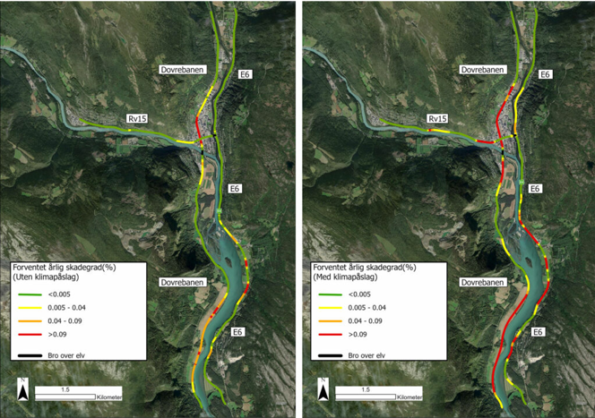
The direct annual costs of damage on the railway Dovrebanen, and the main roads E6 and Rv15 are estimated to NOK 1.087.239, NOK 604.071 and NOK 59.859, respectively, when accounting for climate change. By including the climate effect, the cost related to direct damages increased by 635% for E6, 899% for Rv15 and 507% for the railway Dovrebanen (Figure 1). Dovrebanen has the highest costs related to flooding in the study areas, however, the section of highest risk is located at E6 south of where the rivers merge. The applied damage functions used are not ideal for analysis requiring a high level of detail. The functions can be improved by considering the shape and construction of the infrastructure, as well as including more variables as durations and velocity.

Figure 2: Expected annual degree of damage without (left) and with (right) climate effect.
Indirect costs are estimated using an innovative approach based on average exceedance duration. This method provides an estimate of the total costs which is difficult to obtain by analyzing specific flood occurrences, only, and is found suitable for this type of analysis. The method is also transferable to other study areas. However, the “down-time” due to repair is not considered, and this is assumed to be significant. According to the flood modelling the will increase with the prospected changes in climate.
It is expected that E6 will close at 50-years flood levels, and due to long detour alternatives, time- and fuel costs for a closure is estimated to an average of 1.736.000 NOK. The Rv15 will only close with a 200-year flood, and comparable indirect costs per closure are 225.285 NOK. The railway is estimated to close every time the flood levels exceed the 50-year flood, and indirect costs of one closure is estimated to 197.842 NOK. It is expected that the increased frequency of closures due to climate change will affect the indirect cost even more than the direct costs. However, because the costs related to the duration of closure are based on the current situation, the indirect costs are only calculated based on today’s climate.
The modelled flood hazard maps show good agreement with previous flood maps from the area. However, the higher level of detail and larger coverage of the flood maps presented here improves the usability for consequence analysis.